Beth and I are leaving Phoenix Sep 13 and retuning Sep 19 for our fourth trip to the area. Our High Altitude Expedition - 2008 headquarters will be the Comfort Inn in Ouray (nice place, clean, but a tad expensive and the only chain motel in the area). Being old farts, our camping days are behind us, the temps in mid-Sep range from the low 30's to the low to mid 70's... too cold for us to be sleeping under the stars.
durangotang wrote:
So if you are willing to swing by this summer then sound off here...
If you have already been on the trails in the area then you can help us all out with a little info:
1. Can you make it to LJS 2009?
2. What trails have you run?
3. What would you be comfortable leading?
4. Recommendations or comments?
1. Yes, we'll be there!!!
2. Using Wells' book, Area 1 as a guide, we've done:
- #2 Yankee Boy Basin (M)
- #3 Imogene Pass (M)
- #4 Black Bear Pass
(D)
- #5 Ophir Pass (M)
- #6 Clear Lake (M)
- #7 Engineer Pass (M)
- #8 Cinnamon Pass (M)
- #10 Picayne & Placer Gulch (M)
- #11 Corkscrew Gulch (M)
- #12 California Gulch (M)
- #15 Stony Pass (M)
- #16 Maggie Gulch (M)
- #17 Minnie Gulch (M)
And a few others that aren't in the book such as:
- Last Dollar Road (E)
- Brooklyn Road (E)
3. Any of them
4. Comments:
- All of the above trails can be done in a stock height KJ with good tires and full skids.
- IMO, Wells has overated all of the trails in this section of his book. Even the infamous Black Bear Pass is not all that difficult, but it earns a
(D) rating due to a high pucker factor because of the tight switchbacks way above Telluride that requires some three and four point turns. Other than the 'Steps', which is off camber to the outside looking 1,000 ft down a cliff, you just have to pay a little more attention than normal to what your doing. Warning... if you or anyone with you is afraid of heights, I'd suggest they pass on Black Bear.
- Don't get me wrong. While none of the trails are technically challanging, they are bumpy with plenty of rocks and trails covered with tailings. Bangs and scraps on the bottom side can and do occur. Also, because of the trail sururfaces, there is always the possibility of a blowout.
- Altitude sickness in some degree can and does occur. Breathing can become labored at the higher elevations. Ouray is at the 7,000 ft level. Some people may experience dull headaches at that altitude. All of the other trails and passes are above the 9,000 level with most being at 11,000 - 12,000 feet. Imogine Pass, the second highest pass in Colorado, is at 13,114 ft... can you say, 'got oxygen'?
So, pack a lunch, bring warm clothes you can peel off in layers and plan on being out on the trails all day. Oh, AND bring your camera... we stop for photo ops every chance we get.
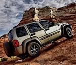
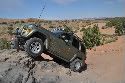
A couple of pics from our High Altitude Expedition - 2007....
Got oxygen??? Trees don't even grow this high up!!!
 Still climbing at 12,000 feet...

AJ