Wrong info. We were not snow stopped; there was a gate closed on the easy way up so we tried to take the hard way and got to a point that without boulder bars could cause body damage. The gate opened the following weekend and is a really tame road like what we ran at Cyrstal Peak.
Info for Signal Peak: Take the Cisco Grove exit off of I-80. The gate for Forest Route 85 is at N39°18.729', W120°32.657'. Stay on the well traveled road. There are some signed intersections/forks along the road on your way up. Always bear to the left and when you reach N39°20.677', W120°30.460' turn left to make the final climb up. The road becomes more narrow and a little rocky now. This is where you will want to shift into four wheel drive. Park at N39°20.281', W120°32.208' and walk a very short distance to the lookout.
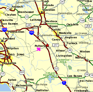
As for August I'd like to suggest Frank Raines OHV park. Not sure where everyone is located, but about an hour drive from Sacramento. I've been there twice and it's a lot of fun with greatly varied terrain; rocks,hill climbs, river crossing, mud pits. At one time I thought this was a State OHV park, now it appears to be under the Stanislaus County authority.
http://www.co.stanislaus.ca.us/ER/PARKS/pdf/FrankRainesRegionalPark.pdf